
A few days ago Pierre Fetet learned of a map which immediately called his attention.
That map displays at the same time precise and unsettling measurements. Not knowing Japanese, Pierre Fetet asked Kurumi Sugita, the president of Nos voisins lointains 3.11 association, to translate for him the text. She immediately accepted and explained to him what it was:
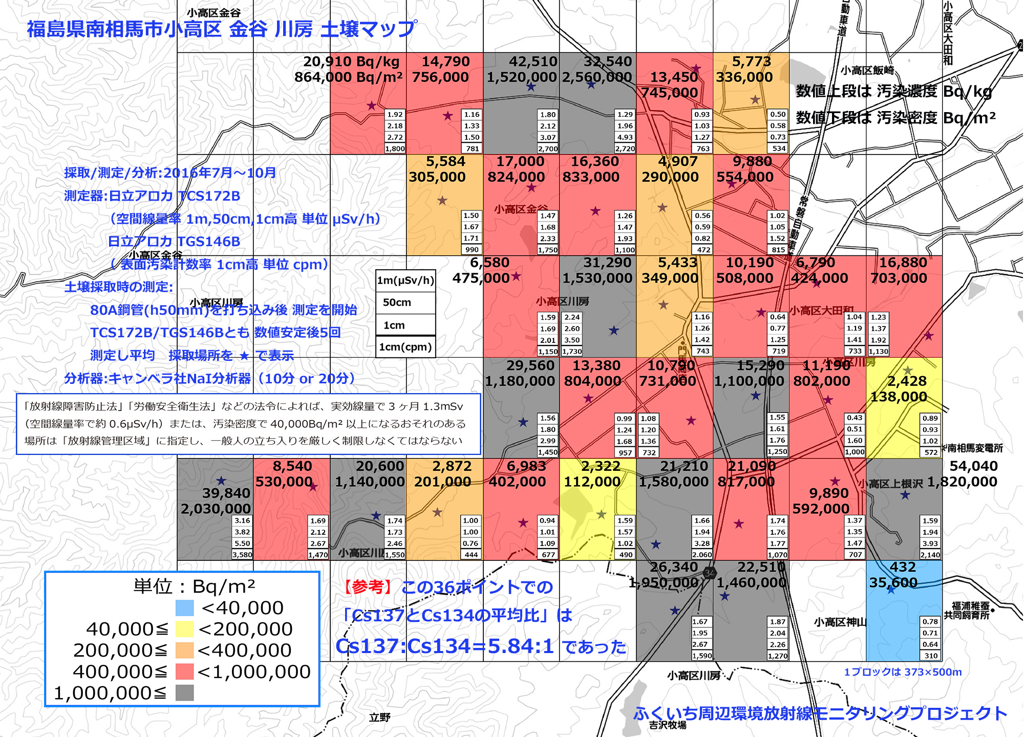
“The project to measure environmental radioactivity around the Fukushima Daiichi nuclear power plant (“Fukuichi Area Environmental Radiation Monitoring Project“) is conducted by a team of relatively old volunteers (who are less radiosensitive than youth) to perform radioactivity measurements with a tight mesh size of 75 x 100 m for radioactivity in air and 375 x 500 m for soil contamination. Measurements of ambient radioactivity and soil radioactivity are carried out mainly in the city of Minamisōma and its surroundings. They try to make detailed measurements so as to show the inhabitants the real conditions of their lives, and also to accumulate data for the analysis of long-term health and environmental damages.”
Thanks to the Kurumi Sugita’s translation and with the agreement of Mr. Ozawa, author of the document, Pierre Fetet was able to make a French version of this map, which I translated into english here below:

Map of Mr. Ozawa’s team, “Fukuichi Area Environmental Radiation Monitoring Project” (translation first by Kurumi Sugita, then by Hervé Courtois)
In the context of the normalization of contaminated areas into habitable areas, the evacuation order of the Odaka district of the city of Minamisōma was lifted on 12 July 2016, except the area bordering Namie (Hamlet of Ohatake where a single household lives) classified as a “difficult return” area.

Situation of the study area
The contamination map examines the Kanaya and Kawabusa areas of the Odaka district, about fifteen kilometers from the former Fukushima Daiichi nuclear power plant. Mr. Ozawa, the engineer who launched this investigation, has chosen the precision of the measurements, that is to say laboratory scintillation radiometers are used to measure radioactivity: Hitachi Aloka TCS172B, Hitachi Aloka TGS146B and Canberra NaI Scintillation Detector.
The originality of this map is due as much to the quality of its realization as to the abundance of its informations: it can be read, for each of the 36 samples taken, measurements in Bq / m², in Bq / kg, in μSv / h at three different soil heights (1 m, 50 cm, 1 cm) And in cpm (counts per minute) at the height of 1 cm. For those who know a little about radioactivity, these informations are very valuable informations. Usually, measurements are given in either unit, but never simultaneously with 4 units. Official organizations should learn this way of working.
The measures revealed by the map are very disturbing. They show that the earth has a level of contamination that would make it a radioactive waste in any uncontaminated country. As Mr. Ozawa writes, these lands should be considered a “controlled zone”, that is to say a secure space, as in nuclear power plants, where the doses received must be constantly checked. In fact, it is worse than inside of a nuclear power plant because in Japan the inhabitants evacuated since five and a half years are now asked to return home, whereas it is known that they will be irradiated (Up to 20 mSv / year) and contaminated (by inhalation and ingestion).
This citizen research is remarkable in more ways than one:
- It is independent of any organization. There is no lobby to alter or play down this or that measure. These are just raw data, taken by honest people, in search of truth.
- It respects a scientific protocol, explained on the map. There will always be people to criticize this or that aspect of the process, But this one is rigorous and objective.
- It takes measurements 1 m from the ground but also 1 cm from the ground. This approach is more logical because until now men are walking on the ground no? The contamination maps of Japan often show measurements at 1 m from the ground, Which does not reflect reality and seems to be done to minimize the facts. Indeed, the measurement is often twice as high at 1 cm from the ground as at 1 m.
- It acts as a revealing map. Mr. Ozawa and his team are whistleblowers. Their maps say: Watch out ! Laws contradict each other in Japan. What the government claims, namely that a dose of 20 mSv / year will not produce any health effect, is not necessarily the truth. If you come back, you are going to be irradiated and contaminated.
France is preparing for the same forfeiture, namely that ‘it is transposing into national law the provisions of Directive 2013/59 / Euratom: the French authorities retained the upper limit of the interval: 100 mSv for the emergency phase and 20 mSv for the following 12 months (And for the following years there is no guarantee that this reference level will not be renewed). These values apply to all, including infants, children and pregnant women! ” (source Criirad)
The Japanese government is asking residents to return home and abolishing compensation for evacuees. The Olympics are coming, Fukushima must be perceived as “normal” so that the athletes and supporters of the whole world won’t be afraid, even if it means sacrificing the health of the local population. It is therefore necessary to make known the map of Mr. Ozawa so that future advertising campaigns do not stifle the reality of the facts.
Pierre Fetet
Data on measurements at Minamisōma
http://www.f1-monitoring-project.jp/open_deta.html
Website of the measuring team: Fukuichi Area Environmental Radiation Monitoring Project
http://www.f1-monitoring-project.jp/index.html
Address of the original map (HD)
http://www.f1-monitoring-project.jp/dirtsfiles/20161104-Odaka-Kanaya-Kawabusa-s.jpg

Source : Article of Pierre Fetet
http://www.fukushima-blog.com/2016/11/alerte-a-minamisoma.html
(Translation Hervé Courtois)
